

Services
Calvary Wildlife Drone Services, LLC provides a wide array of commercial drone services to the public. Our primary focus is working with hunters and landowners through wildlife management and downed deer recoveries. In addition to these, we also provide such services as surveying the extent of hog invasion on your property, searching for lost pets or livestock, showcasing your home and property for sale, monitoring construction projects, and helping you be a good steward of you land with aerial photography and videography.
Drones are fast becoming mission-critical tools for a multitude of wildlife and property management operations. From herd management, to pre-season scouting, post-shot recovery, feral hog patterning, and property stewardship and showcasing, drones extend range, speed, and safety. Thermal payloads, zoom optics, and night lighting give teams real-time data from drones for deer recovery, pet/livestock locating, aerial property assessments, and feral hog remediation. Flights allow you to gather information, document decisions, reduce ground/animal disturbance, and support rapid ethical recovery.
If you think we can help you in one of these endeavors OR if you have another need you think we can help with, then reach out to us. We are open to other services and look forward to collaborating with you on your idea.
Whatever your needs are, we stand ready to assist you


Whitetail Recovery
No one wants to have a bad shot, resulting in a wounded animal being out in the woods suffering. But, when this happens, ethical hunting standards dictate that you use every means at your disposal to locate and recover them. Drone use is an innovative method of searching for and aiding in the recovery of a lost harvested animals. Drones allow for you to:
-Use thermographic imagery and 8K imagery to conduct a detailed search of the area of interest
-Conduct a detailed, systematic search pattern of the target location and surrounding terrain
-If located, identify the condition of target animal (wounded or
deceased)
-When found deceased, provide a location pin to your favorite
hunting app for recovery
-When target animal is found wounded, law requires requires we
stop the recovery immediately without providing any locating
information to the customer


Deer Herd Census
As hunters and owners of the land that God has graced us with, it is our duty to be good stewards of His gifts. When applying that to deer herd management on your property, drones can be an invaluable tool for:
-Utilizing advanced aerial technology to provide accurate and detailed insights into deer populations
-Provides more accurate data than standard trail cams, which gives you an estimate of your deer population
-Gathering information on buck-to-doe ratio, birth rates, buck habitats, and movement trends in the area
-Able to conduct a detailed survey of large areas in a short amount of time
-Able to search difficult, hard to access terrain using thermal imaging, spotlights and 8K imagery
-Conduct the search with minimal disturbance of wildlife in the target habitat
-More cost effective compared to traditional methods such as the use of a helicopter surveys
-Provide detailed information to help the client make informed decisions regarding population management goals, habitat improvements, predator concerns, etc.


Hog Invasion Patterning
Feral hogs can have a significant negative impact on some livestock operations through depredation and damage to facilities and fences. Farmers and ranchers also share a significant portion of the damage caused by the rooting of fields, depredation of crops, and the destruction of fences. But the biggest impact of feral hogs is how they displace native wildlife and compete for limited food resources.
-Use unmanned aerial vehicles to survey large agricultural/hunting areas.
-Use aerial photography to create a chronological assessment of property conditions.
-Map rooting damage with drones for feral hog control plans.
-Track feral sounder movement and activity trends through the property.
-Collect aerial images of the property, taken at different times of the year, to give you a detailed tracking of the extent of feral hog damage.
-Thermal imaging gives you the ability to see hog population, even when under the coverage of foliage.


Pet / Livestock Recovery
There are many reasons why pets might go missing. Animals can stray or be frightened away from their normal environment. Reasons can range from escape through an open door or gate, fright from fireworks or thunderstorms, to natural disasters. When an animal is lost, time is of the essence in the recovery operations. Drones allow for you to:
-Conduct a detailed, systematic search pattern of the target location and surrounding terrain
-Use thermographic imagery and 8K imagery in the rapid detection of the lost animal, especially in a low light environment
-If located, identify the condition of recovery animal(s)
-Prevent a lost/scared animal from being bumped/pushed during the recovery search
-When found, provide a location pin to your favorite GPS app for recovery
-Once located, use drone perspective to identify potential routes for recovery of the animal(s)


Property Stewardship
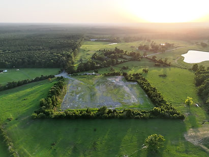
Drones can improve farm/land management by providing the stewards with aerial imagery of their property. This perspective reveals data points such as infrastructure, terrain, water source conditions, pasture health, crop growth, and soil conditions in a rapid, lower cost method. They allow stewards to:
-Assess the property from a wide view, top down perspective
-Inspect hard-to-reach areas on the property
-Rapidly monitor hard-to-reach areas
-Assess pasture/property vegetation and cash crop health
-Monitor water and soil conditions such as erosion and water source stressors
-Identify issues such as pest infestations and hog invasion
-The inspection of infrastructure such as outbuildings and structures
-Monitor and maintain property fencing
-Identify damage quickly
-Plan/prioritize work
-Monitor domestic animal stock location and current conditions
-Track livestock habits, use of and movement within the property boundaries
-Monitor wildlife species without disrupting their habitat
-Track seasonal conditions as they impact property operations
If you are planning to upgrade/sell your property, drones can offer you a wide array of services that will aid in your efforts. Drones:
-Provide high resolution aerial photography of the property
-Showcase your property with beautiful cinematic aerial video
-Capture detailed imagery to monitor progress, gather data, and highlight completed construction projects
-Capture images from various altitudes, distances, and directions to give you the full picture of your project/property
-Updates on a weekly, monthly, or yearly basis to understand how your project is progressing dependent service contract




Whatever your needs are, we stand ready to assist you


